Keykubad Way Route Map
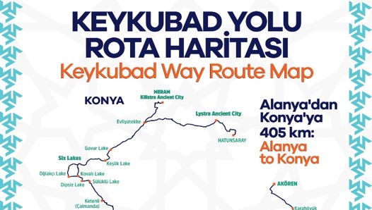
Keykubad Way Route Map
The Keykubad Migration and Caravan Route stands as a unique project that brings together thousands of years of Anatolia’s history, culture, and natural beauty. Stretching a total of 405 km, this route carries countless stories—from the conquests of Seljuk Sultan Alaeddin Keykubad to the millennia-old footsteps of nomadic communities, from ancient caravan trade networks to the breathtaking landscapes of the Taurus Mountains.
TRACES OF THOUSANDS OF YEARS OF MIGRATION AND THE SILK ROAD
The story of this route dates back to the Hellenistic period and continued to be used by Cilicians, Romans, and Seljuks as a historical caravan road. At the same time, it served as a migration path for Yörüks and nomadic tribes, preserving traces of thousands of years of movement.
Every stone, village, and monument you encounter along the way forms a part of this ancient story. The route, which continues along the Alara Valley in Alanya, spreads from the highland plateaus at the foothills of the Geyik Mountains to glacial lakes and the vast plains of the Konya steppe.
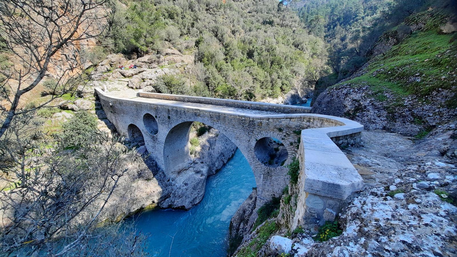
As one of the most vibrant arteries of the Silk Road in Anatolia, the Keykubad Route carried not only trade but also science and art. After Alaeddin Keykubad conquered Alanya in 1221, the city became a gateway through which Chinese silk and Indian spices reached Europe. Today, restored caravanserais and stone-paved roads revive this ancient heritage.
NATURE, WATER, AND THE RHYTHM OF LIFE
The Keykubad Route passes through the mysterious geography of the Taşeli Plateau. Snow falling on the Geyik Mountains during winter melts in spring, feeding the Alara River. Waters accumulating in sinkholes, including Sarıot Lake, sometimes form small lakes, while underground water sources sustain life in the region.
With the arrival of May, the highland migrations begin. Lush green plateaus, thyme-scented air, and slopes covered with endemic plants turn the landscape into a natural festival. Along the route, wild goats, partridges, and eagles accompany the rhythm of nature.
LIVING CULTURE OF THE HIGHLANDS
The traces of nomadic life are still vivid in the highlands. Historical cemeteries reflect ancient burial traditions rooted in freedom and nature. This land, filled with tales of outlaws and legends, hides a secret beneath every stone.
In the villages along the route, visitors can experience natural local products such as traditional cheeses, fresh milk, and goat meat. Herbal teas and local pastries offer both refreshment and healing for weary travelers.
The Keykubad Route is not just a trail; it is a heritage stretching from Çatalhöyük to the Seljuk era. Road networks shaped during the Roman and Byzantine periods were further developed by Seljuk caravanserais, becoming one of the foundations of intercultural exchange and peace.
THE ROAD TO KEYKUBAD’S VICTORY IN ALANYA
In the autumn of 1221, Seljuk Sultan Alaeddin Keykubad set out on an epic journey from Konya to Alanya with tens of thousands of soldiers, horses, and camels. Today, this historic path—known as the Keykubad Conquest Route—awaits history and nature enthusiasts.
Starting from Akören in Konya, the route extends through the ancient corridors of the Blue Gorge Canyon, along the murmuring waters of the Çarşamba Stream, and to Sarıot Lake, which still carries traces of Roman legionnaires. Walking along stone-paved paths once used by caravans loaded with war equipment, visitors experience the thrill of crossing the challenging passes of the Taurus Mountains.
In Çağlayan, where an ancient wheat mill still operates, and in Dereköy, where travelers are welcomed with traditional tahini treats, the journey continues accompanied by the roaring Aygırdibi Waterfall. Along the way, visitors witness the Roman tomb in Kapı İni Cave, the geological secrets of Susam Pass, and the Hellenistic Kırk Dönme Caravan Route.
The route ultimately reaches the 13th-century Alarahan Caravanserai, evoking the grandeur of the Sultan’s victory. In the future, the journey will expand through unexplored branches mentioned by Ibn Bibi, connecting to the ancient city of Karalia, passing through Kanlı Dere (Fığla Stream), and extending toward the ancient city of Ptolemais—continuing the adventure beyond the known path.